Stratigraphy and Localities
The fossils in this study have come from two units of the Late Devonian Ohio Shale; the dark colored Chagrin Shale and the overlying black Cleveland Shale (Fammenian). These shales are exposed along the southern shore of Lake Erie for 150 kilometers and extensively along many of the streams draining into the lake. The Devonian shale outcrop belt in northeast Ohio is illustrated in Figure 2, along with the known sites from which "spathiocarids" have been collected. The Ohio Shale represents prograding distal deposition of fine-grained sediments from the Catskill Delta to the east during a time of marine transgression in the Appalachian Basin (Lewis, 1988).
Prosser first used the name "Chagrin Shale" to describe the unit of interbedded gray shales and siltstones which Newberry called the "Erie Shale", as the latter term was preoccupied (Prosser, 1912, pp.14-15). The unit is a wedge-shaped body thickening eastward into western Pennsylvania, where it is correlative with the Riceville Shale. It is underlain by the Huron Shale, another black shale member of the Ohio Shale. The Chagrin thins westward and pinches out east of the Huron River (Lewis, 1988). The Chagrin Shale consists primarily of greenish-gray or bluish-gray clayey shales interbedded with discontinuous siltstones. The shales frequently are bioturbated and often contain other traces of benthic life (Barron and Ettensohn, 1981; Hannibal and Feldmann, 1983; Schwimmer, 1988, 1990). They represent gradual deposition within a dysaerobic low-energy environment (Barron and Ettensohn, 1981). The siltstones probably represent episodic storm events, washing coarser deltaic sediments westward in the basin (Hannibal and Feldmann, 1983).
The Cleveland Shale, named by Newberry in 1870, thins both eastward and westward from its maximum thickness west of Cleveland (Lewis, 1988). It consists primarily of black, laminated, fissile shales containing more organic matter and quartz and less clay (illite) than the gray shales of the Chagrin (Broadhead, et al., 1982). The lack of an active benthos and the enrichment in sulfides and organics indicates that the Cleveland Shale was deposited in deeper, anoxic conditions (Barron and Ettensohn, 1981). While it lies over the Chagrin Shale, there is a general west-east transition between the two units as the gray Chagrin grades westward into the black Cleveland Shale (Prosser, 1912; Szmuc, 1970a). The Cleveland Shale is overlain in turn by the Bedford Formation. The contact is sharp but conformable, marked by a thin bed of pyritized brachiopods and vertebrate fragments (Szmuc, 1970b).
Localities.--The known localities at which these fossils have been found are listed here, in order from west to east. The numbers correspond to those on the map in Figure 2.
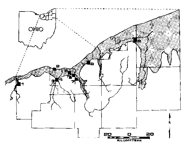
1. Chance Creek.--An easterly tributary of the Vermilion River in Lorain County. Kipton 7.5 Minute Quadrangle, Brownhelm Township, T6N R19W, 41 21'40"N, 82 18'00"W. Exposures occur on Chance Creek, four hundred meters south of the intersection of Vermilion Road and Gifford Road. The Cleveland Shale in this region is approximately 15 meters thick (Lewis, 1988). Specimens CMNH 3744, 3746, and 3747 were collected by William J. Hlavin from a zone 0.5 to 1.5 m below the Cleveland-Bedford formational contact. "The base of the invertebrate zone is characterized by a thin bone bed which contains water-worn, disarticulated elements and teeth of fossil fish" (Hlavin, 1976).
2. Cahoon Cliffs.--Cliffs along the Lake Erie shore in Bay Village, Ohio. North Olmstead 7.5 Minute Quadrangle, T7N, R15W, 41 29'15"N, 81 55'30"W. The ten-meter cliff east of the mouth of Cahoon Creek is an excellent exposure of the Chagrin Shale (Prosser, 1912). CMNH 6620 was collected as float along the beach, 100 meters east of the creek mouth.
3. Little Cedar Point.--A bluff at the confluence of the East and West branches of the Rocky River. North Olmstead 7.5 Minute Quadrangle, T6N, R15W, 41 24'40"N, 81 53'20"W. The Cleveland Shale in this area forms steep, high cliffs along the river. The thickness of the unit appears to be 30 meters, with the upper third somewhat more resistant than the rest (Prosser, 1912). Numerous concretions, cone-in-cone structures, and pyrite nodules have been found in the Cleveland Shale in this area. Forty-four specimens were located in the collections of the Cleveland Museum of Natural History in association with labels which read, "100 yds. E of ford at base of Little Cedar Point, 6/24/51" and "5/29/51, in a landslide." Although it is not clear which specimens, if any, are rightfully associated with these labels, the locality has been productive of both vertebrate and invertebrate material.
4. Abram's Creek.--A southerly tributary of the Rocky River. Lakewood 7.5 Minute Quadrangle, T6N, R14W, 41 25'05"N, 81 52'00"W. CMNH 8312 was collected where Abram's Creek meets Rocky River, not far downstream from Little Cedar Point.
5. Big Creek Localities.--Along Big Creek from Brookside Park to the Big Creek Metropark and beyond, the upper 30 meters of the Chagrin and at least 15 meters of the Cleveland are exposed. The Cleveland appears at the top of the cliffs on the south side of the creek just above Brookside Park; about three kilometers upstream it reaches the stream bed south of West Park Cemetery, near the western edge of the Cleveland South Quadrangle (Prosser, 1912).
Localities in the upper reaches of Big Creek include four along the northwest branch of the creek, and a region west of Linndale and north of Memphis Road. The fossils were collected as float and occasionally in situ in the creek bed. Lakewood 7.5 Minute Quadrangle:
5a. 30 meters east of W. 140th St., T7N, R14W, 41 26'15"N, 81 47'30"W. CMNH 8317.
5b. First bend below W. 130th St., T7N, R13W, 41 26'15"N, 81 46'45"W. CMNH 8304.
5c. Above W. 128th St., T7N, R13W, 41 27'00"N, 81 46'45"W. CMNH 8303, CMNH 8315, CMNH 8316, CMNH 8318.
5d. At W. 117th St. T7N, R13W, 41 27'15"N, 81 46'00"W. CMNH 3745.
5e. Region of the Metropark north of Memphis Road, T7N, R13W, 41 23'45"N to 41 26'30"N, 81 45'15"W to 81 45'30"W. CMNH 7942, CMNH 8159, CMNH 8306, CMNH 8309, CMNH 8310, CMNH 8311, CMNH 8314.
6. Brookside Park.--Located along Big Creek between the Big Creek Metropark and the creek's terminus at the Cuyahoga River. Trace fossils have been collected as float along the base of outcrops south of Big Creek in this area (Hannibal and Feldmann, 1983). Cleveland South 7.5 Minute Quadrangle, T7N, R13W, 41 26'30"N to 41 B7'30"N, 81 42'15"W to 81 44'00"W. CMNH 8305, CMNH 8307, CMNH 8313.
7. Skinner's Run.--On the border of Brooklyn Heights, Parma, and Seven Hills, Ohio. The Chagrin and the Cleveland are exposed along this tributary of the Cuyahoga River. At their contact is the Skinner's Run pyrite bed (Hlavin, 1976), a pyritized lag deposit enriched in fossils. Specimens were collected from the lower portion of the Cleveland Shale, somewhat above the pyrite bed. South central 1/9th of the Cleveland South 7.5 Minute Quadrangle, T6N, R12W, 41 24'30"N, 81 40'30"W.
8. Euclid Creek.--East of Cleveland, in Euclid. The Chagrin Shale is exposed along Euclid Creek's west branch in the Euclid Creek Metropark. East Cleveland 7.5 Minute Quadrangle, T8N, R11W, 41 33'00"N, 81 31'45"W. CMNH 6576 was collected in situ north of a small gully extending from the park road, 1.8 km (1.1 miles) south along the park road from its intersection with Highland Road.
9. Mill Creek.--Camp Stigwandish, Lake County, Ohio. The Chagrin Shale is exposed in the cliffs along this tributary of the Grand River. Thompson 7.5 Minute Quadrangle, T11N, R6W, 41 44'15"N, 81 02'00"W. CMNH 7948, collected as float from a steep cliff on the west side of the stream, 87 meters upstream from the Doty Road bridge.